By Sarah Lockhart and Thomas Hoctor, University of Florida
Florida added nearly 3 million residents from 2010-2020, making it the fastest-growing state in the United States during that time.
On any given day, a Florida county commission or municipality may approve a new subdivision, a transportation agency may select the route of a highway expansion, or a rancher may decide whether to sell land for development. As new neighborhoods, roads and infrastructure spread across the state, they reshape not only communities but also the natural systems wildlife depends on.
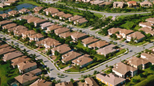
Each decision is local and incremental. But taken together, these choices determine whether wildlife can move across Florida’s landscapes to find food, reproduce and adapt to a changing climate – or become isolated in shrinking fragments of habitat.
In 2011, Florida eliminated the Department of Community Affairs, which had monitored and coordinated land use and development throughout the state. Since then, there has been limited oversight of local and county governments when it comes to urban planning and land development.
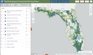
As conservation researchers, we study how scientific data can support real-world planning decisions. That led us to develop the Florida Ecological Connectivity Planning Viewer in collaboration with our colleagues at the University of Florida’s Center for Landscape Conservation Planning and GeoPlan Center. We call it the EcoCon.
This online mapping platform helps decision-makers and conservationists understand how land across Florida fits together as a connected ecological network. Seeing this network alongside a suite of other related planning and conservation data can help them avoid impacts that would disrupt or disconnect it.
A cautionary tale from the ‘Last Green Thread’
Scientists have known for decades that connected landscapes benefit both animals and people. Large, connected ecosystems help protect drinking water supplies, reduce flooding and support agriculture, recreation and tourism. They can also be more resilient to climate pressures, such as stronger storms and changing rainfall patterns.
The challenge today is not proving that connectivity matters. It is helping people see how thousands of everyday land-use decisions add up to create, or break, those connections.
A clear example of this challenge can be found in central Florida, about 20 miles southwest of Orlando. Since the early 1990s, conservation scientists have identified a narrow stretch of land known as the “Last Green Thread.” This thread is one of the few remaining opportunities to maintain a continuous ecological connection between protected lands in the Green Swamp, the source of four of Florida’s rivers, and the headwaters of the Everglades to the south.
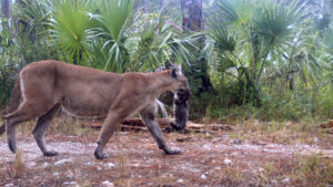
This corridor still remains. But it is a shrinking sliver on its way to completely disappearing as land use decisions continue to make it less functional. An intact corridor helps species such as the Florida black bear, and potentially the endangered Florida panther, move between habitats. It also benefits other animals that are sensitive to fragmentation, including bobcats, otters, scrub jays, alligators and gopher tortoises.
No single decision has eliminated this corridor. Over time, however, development has gradually filled in significant parts of this landscape. Subdivisions and infrastructure have spread across multiple private properties and public jurisdictions. The result is a fragmented pathway between major conservation areas in south and central Florida.
A new way to see the landscape
Researchers have spent decades mapping wildlife habitat and ecological connections using geographic information systems. These digital tools help identify where important ecological links exist across landscapes.
But this data has not always been easy for planners, communities and landowners to access. Information may be scattered across agencies, universities and technical reports, or it may require expensive software tools and expertise to access.
When different decision-makers rely on different maps – or none at all – it becomes difficult to see how individual land-use decisions affect the larger ecological network.
This is where the EcoCon comes in.
With a few clicks, users can turn different layers on and off. These layers include wildlife movement pathways, protected conservation lands, wildlife crossings, water resources, agricultural areas and more. Instead of looking at these pieces separately, the EcoCon shows how they overlap.
The wildlife connectivity data comes from scientific models that estimate how animals move across the landscape. Using information such as land cover, habitat quality and barriers, including roads and development, these models highlight the routes animals are most likely to take between large natural areas.
By bringing this information together in a single, easy-to-use, publicly accessible mapping tool, the EcoCon helps planners see how proposed changes to the landscape might affect wildlife and natural resources.
Using the EcoCon isn’t about stopping development. Rather, it gives decision-makers a clearer picture so they can make informed, coordinated plans for growth in ways that better support both people and wildlife.
Tools like the EcoCon can also support broader conservation initiatives such as the Florida Wildlife Corridor, a statewide network of connected public and private lands that helps wildlife move across the state.
In fast-growing Florida, this visibility may be one of the most important tools for ensuring that wildlife and people can continue to share the same landscape in a rapidly changing world.![]()
Sarah Lockhart is a Ph.D. candidate in interdisciplinary ecology and Thomas Hoctor is a research associate professor of landscape architecture, both at the University of Florida.
This article is republished from The Conversation under a Creative Commons license. Read the original article. Banner photo: A black bear in a residential neighborhood in Florida (iStock image).
Sign up for The Invading Sea newsletter by visiting here. To support The Invading Sea, click here to make a donation. If you are interested in submitting an opinion piece to The Invading Sea, email Editor Nathan Crabbe. To learn more about the Florida Wildlife Corridor, watch the short video below.

Cool to see how planning is evolving to protect wildlife. What kind of wildlife corridors are most at risk?