By Franco Montalto, Drexel University
“When it rains, it pours” once was a metaphor for bad things happening in clusters. Now it’s becoming a statement of fact about rainfall in a changing climate.
Across the continental U.S., intense single-day precipitation events are growing more frequent, fueled by warming air that can hold increasing levels of moisture. Most recently, areas north of Houston received 12 to 20 inches (30 to 50 centimeters) of rain in several days in early May 2024, leading to swamped roads and evacuations.

Earlier in the year, San Diego received 2.72 inches (7 centimeters) of rain on Jan. 22 that damaged nearly 600 homes and displaced about 1,200 people. Two weeks later, an atmospheric river dumped 5 to 10 inches (12 to 25 centimeters) of rain on Los Angeles, causing widespread mudslides and leaving more than a million people without power.
Events like these have sparked interest in so-called sponge cities – a comprehensive approach to urban flood mitigation that uses innovative landscape and drainage designs to reduce and slow down runoff, while allowing certain parts of the city to flood safely during extreme weather. Sponge city techniques differ from other stormwater management approaches because they are scaled to much larger storms and need to be applied across nearly all urban surfaces.
I’m a water resources engineer who studies and designs strategies for sustainably managing urban stormwater. In response to recent flooding episodes, some U.S. cities are beginning to take steps toward incorporation of sponge city concepts into their stormwater management plans, but most of these projects are still pilots. If this concept is to evolve into the new standard for urban design, city officials and developers will need to find ways to scale up and accelerate this work.
The problem of stormwater
For more than a century after U.S. cities started installing centralized sewage systems in the mid-1800s, pipes carried stormwater – rain or melted snow that runs off streets and buildings – to nearby rivers or harbors. This approach reduced local flooding but polluted adjoining waters and exacerbated flood risks further downstream.

The 1972 Clean Water Act was designed to make the nation’s waters fishable and swimmable by 1983 but failed to meet that goal. One major reason was that the law initially focused on reducing only point sources – pollution discharges that came from an identifiable source, such as a pipe discharging human or industrial waste.
In the late 1980s, Congress amended the law to address nonpoint, or diffuse, water pollution sources, including stormwater. Engineers began designing systems to capture sediments in the “first flush” of runoff, since harmful pollutants such as heavy metals were believed to adhere to these particles.
To this day, green infrastructure and other stormwater management practices in the U.S. are typically designed to detain, retain or filter only the first 1 to 2 inches (2.5 to 5 centimeters) of runoff. Individually, they can’t capture all the runoff generated during larger storms, the kind of events that are becoming more frequent due to climate change. What’s more, stormwater management frequently is not required on smaller land parcels, which can collectively represent a large fraction of urban watersheds.
All of these factors limit green infrastructure’s ability to reduce flood risks.
Greening infrastructure, bit by bit
The term “sponge city” originated in China around 2010, but U.S. cities have employed similar ideas since the 1970s to improve water quality in rivers and streams.
In the early 2000s, the idea of designing communities to filter and soak up stormwater became known as green infrastructure. Regulators and utilities saw it as a potentially cost-effective strategy for complying with federal clean water regulations. In cities where existing storm sewage systems discharged directly to creeks, lakes and rivers, green infrastructure had the potential to filter out pollutants from stormwater before it flowed into those waterways.
In hundreds of cities, mainly in the Northeast and Midwest, stormwater and wastewater are carried in the same sewage pipes. Green infrastructure offered a strategy for diverting stormwater away from the sewage system to places where it could soak into the ground. That helped reduce the chances of sewage systems overflowing and sending untreated stormwater and wastewater into local waters.
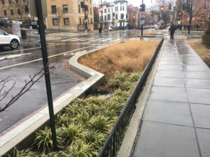
Cities including Philadelphia, New York, Cincinnati, San Francisco, Cleveland, Washington, D.C., and Kansas City, Missouri, have spent billions of dollars over the past 20 years to retrofit developed landscapes with rain gardens, green roofs, permeable pavements, constructed wetlands and other site-scale stormwater control measures. Most of these systems, however, were installed in areas that produced the most water pollution and were not sized to manage large storms.
In the best cases, green infrastructure has been installed on publicly owned land and required on new or redesigned large-scale developments. It has proved much more challenging to incorporate green infrastructure on smaller, privately owned land parcels, which collectively make up a significant percentage of urban watershed areas.
In some cities, some new development is still approved without any required stormwater treatment system or analysis of the dramatic ways in which its stormwater could cause flooding on downstream and adjacent properties. And in many cities, stormwater from small land parcels is allowed to pass without treatment into piped sewage systems. If many such parcels are located in the same neighborhood, this common practice can augment downstream flood risks.
Every surface matters
In my lab at Drexel University we are studying solutions to flooding in the Eastwick section of southwest Philadelphia. This neighborhood sits at the downstream end of a 77-square-mile suburban watershed. When it rains heavily upstream, Eastwick floods. In 2020, Tropical Storm Isaias flooded some homes with more than 4 feet (1.2 meters) of water.
Our computer models suggest that if conventional green infrastructure had been in place to treat runoff from 65% of the watershed’s impervious surfaces, Isaias would not have caused Eastwick to flood. But that’s five times more treatment than upstream communities are planning as part of their state-mandated stormwater pollutant reduction plans.
Some critics say this level of greening is not technically, logistically or socially feasible. But if the notion of sponge cities is to become a reality, cities will eventually have to figure out how to get there.
To get to 65%, these towns would need to treat runoff from nearly all rooftops, parking lots and roadway surfaces in some form of green infrastructure. If dedicated space for new rain gardens and wetlands on the ground is limited, parking lots could be retrofitted with permeable asphalt or concrete that allowed water to pass through it to the ground beneath. Rooftops could be converted into vegetated green roofs that detain and retain stormwater.
In this sponge city vision, streets would be recontoured to direct stormwater to parks and recreational fields built feet below the street surface and designed to flood safely during extreme weather. Existing natural areas would be leveraged for stormwater storage, enhancing their ecology.
Depending on where extreme rainfall occurs, these systems could function individually or together, mimicking the modularity and redundancy found in natural ecosystems.
Finding the money
In sponge cities, every surface needs to be connected to a space that can flood safely. Getting from traditional green infrastructure to sponge cities requires integrated policies, plans and incentives that apply these kinds of solutions wherever rain falls.
Parking lots can be designed to flood and release water slowly. So can basketball courts, parks, plazas and even streets, as prescribed in Copenhagen, Denmark’s Cloudburst management plan.
Such a transformation of the built environment can’t be fully bankrolled by stormwater utilities. These organizations face a dizzying array of regulatory requirements and can’t raise rates above their customers’ ability to pay.
One way to raise more money would be through collaborations between city agencies responsible for upgrades to roadways, parks, schoolyards and other public land that also attract federal dollars, such as New York City’s Cloudburst Resiliency projects.. In some cases, funding from a third party could supplement the effort. One example is a collaboration between New York City and the Trust for Public Land to add green infrastructure features to a Bronx schoolyard to help reduce local flooding.
Cities could also offer incentives for retrofitting and scaling up existing stormwater management systems on private land. A trading system could be set up to sell the residual capacity to nearby property owners who lack onsite stormwater management opportunities.
This strategy isn’t cheap, but neither is inaction. Inland flooding caused $177.9 billion in damage from 1980 to 2022, and billion-dollar disasters are becoming more frequent with climate change.
As extreme weather events become more prevalent, I expect that urban planning and design standards will evolve to include sponge city concepts. And this more robust approach to stormwater management will continue to figure prominently in all kinds of municipal and private design and development decisions.![]()
Franco Montalto is a professor of civil, architectural and environmental engineering and director of the Sustainable Water Resource Engineering Laboratory at Drexel University.
This article is republished from The Conversation under a Creative Commons license. Read the original article.
Sign up for The Invading Sea newsletter by visiting here. If you are interested in submitting an opinion piece to The Invading Sea, email Editor Nathan Crabbe at ncrabbe@fau.edu.


