By Katie Carpenter, Everwild Media
In every natural disaster, the difference in death tolls is based largely on the amount of advance warning given. Think tsunamis, volcanoes, Hurricane Katrina. Here’s a story from 90 years ago that proves the point of why we need the National Oceanic and Atmospheric Administration (NOAA) and National Weather Service now.
Most of us have heard of the notorious Florida hurricanes from 1926 and 1928, when thousands were killed. The hurricane of 1935 also made history, for different reasons. First, it was the first Category 5 hurricane to make landfall in Florida. Second, it gave rise to an unexpected forecasting device we still value today.
In the summer of 1935, an Atlantic hurricane was reported to be forming, but there was little certainty about where it was headed. Local officials were forecasting a landfall in Cuba, so Floridians were pretty relaxed.
Meteorological tools were crude, and forecasts were mainly derived from observations from ships at sea. A young American aviator named Leonard Povey, an expatriate living in Cuba, set out in his biplane to locate the hurricane.
Povey was a self-taught stunt pilot and flight trainer, a daredevil whose lifelong credo was reportedly, “The Lord hates a coward.” He flew into the Florida Straits and right around the storm.
He returned to Cuba with the news – he had located an “inverted funnel cloud” farther north than expected. Cuban officials alerted their colleagues in Florida that the monster storm was seen turning north and heading right for them.
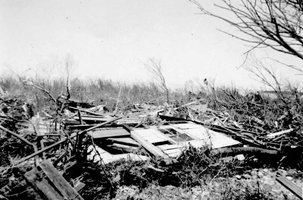
Thankfully, the Overseas Highway was already under construction, so people in the northern Keys were able to drive to safety. Right behind them, winds of up to 200 mph and a 20-foot storm surge destroyed the Overseas Railroad and flattened Islamorada.
The death toll was over 400, and the damage was in the millions of dollars. But without the advance warning from that brave pilot, it could have been much worse.
This matters today, because this spring, we got word that the Hurricane Hunter program was facing budget cuts. The National Weather Service lost nearly 600 jobs to DOGE cuts, and several Hurricane Hunter flight engineers’ jobs were on the line. One was fired – he was probationary – but once they realized his work was critical to public safety, he was rehired. But no one there is really safe.
NOAA’s Aircraft Operations Center is based in Lakeland, where the Hurricane Hunters keep their specialized aircraft until they get the signal. They fly long missions in and out of hurricanes to gather crucial weather data — temperature, humidity, pressure, wind speed, wind direction — that is used to improve hurricane forecasts.
Those multi-colored spaghetti models that make a mess all over your TV screen start to tighten up and form a line, thanks to that data. Then they can show us where the storm will make landfall. If you’re in the evacuation zone, you know it’s time to go.
“A hurricane is basically an organized group of storm clouds,” said meteorologist Kathryn Sellwood at the University of Miami. “And a lot of satellites aren’t good at seeing through clouds. Some may see only through the top layers, the thin cirrus clouds. Others may not be able to see through ice. So, you can’t really see the entire 3D structure of a hurricane just by looking down on it from a satellite.”

“Satellite imaging is like taking an X-ray of a (storm) system from afar,” added Daniel Brown, hurricane specialist at the National Hurricane Center. “The hurricane hunters are measuring the inside of a storm, doing the all-important biopsy.”
Miami meteorologist John Morales expressed concern that NOAA Hurricane Hunter aircraft may be hampered by the budget cuts and not able to fly as much this year. With fewer reconnaissance missions, he said, forecasters like him “may be flying blind.”
A piece of legislation now being considered in Congress could help restore some lost NOAA jobs. The Weather Workforce Improvement Act was just introduced to help fully staff National Weather Service offices across the country. With bipartisan support, the bill seeks to protect them in the future too, by reclassifying meteorologists as critical to public safety, similar to air traffic controllers or FBI agents.
Here in Florida, where more than 40% of U.S. hurricanes hit, that makes a lot of sense. In honor of the 90th anniversary of the first Hurricane Hunter flight, let your reps know you care.
Katie Carpenter is a West Palm Beach-based filmmaker with Everwild Media (www.everwildmedia.com), producing documentaries about conservation, climate change and solutions. Banner photo: An image of Tropical Storm Edouard image taken by scientists aboard a NOAA Hurricane Hunters aircraft (Hurricane Hunters, Public domain, via Wikimedia Commons).
Sign up for The Invading Sea newsletter by visiting here. To support The Invading Sea, click here to make a donation. If you are interested in submitting an opinion piece to The Invading Sea, email Editor Nathan Crabbe at ncrabbe@fau.edu.
