By John L. Renne, Tulane School of Architecture and Built Environment
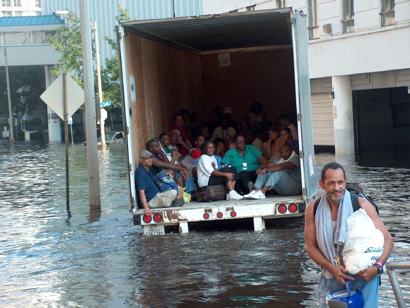
When Hurricane Katrina made landfall in 2005, it exposed the inequities in our transportation system. As evacuees with cars streamed out of New Orleans on contraflow highways, tens of thousands of residents without vehicles were told to head to the Superdome and wait.
The resulting images of suffering and delay resurfaced as we remembered the 20th anniversary. But have we done any better since?
After Hurricane Katrina, I began studying the evacuation plans of major U.S. cities. I examined these 50 large cities in 2005, 2015 and now again in 2025. Based on a simple checklist to gauge how well plans address the different dimensions of evacuation, especially for vulnerable populations, all cities were compared based on the following:
- Special-needs registries: Does the plan identify residents who will need extra help?
- Specialized transportation: Are there buses, vans and paratransit reserved for those who can’t drive?
- Pick-up points: Has the city designated places where people without cars can board evacuation vehicles?
- Multimodal strategies: Does the plan go beyond private cars, tapping transit, trains, ferries and other modes?
- Pedestrian routes: If roads are jammed and transit fails, do officials know where to send people on foot?
Looking back to the 10th anniversary of Katrina, I found that fewer than half of U.S. cities had any public evacuation plan. Only seven cities maintained registries of vulnerable residents, and just 10 cities mapped pick-up sites for the carless. Specialized transportation, multimodal evacuation and pedestrian plans were virtually nonexistent.
By 2015, there was some movement. Two-thirds of cities now posted plans, eight cities offered voluntary registries, 23 detailed specialized transportation, 13 mapped pick-up locations and 29 described multimodal strategies. Yet the research still concluded that progress was only marginal, and many plans remained weak or inaccessible.
This summer, I reexamined the state of plans for all 50 cities in 2025. The good news? Almost every city now publishes some form of an emergency plan and these plans broadly address the needs of vulnerable populations.
What has improved:
- More plans, more modes: Nearly all cities now have an evacuation plan. Multimodal strategies, including buses, trains and ferries, have gone from afterthought to standard practice in 2025.
- Pick-up points are normalized: It is no longer acceptable to tell carless residents to “figure it out.” Most cities now identify specific locations where evacuees can board buses or rail to safety.
- Specialized transport is being addressed: Dozens of cities now outline how paratransit, lift-equipped buses and medical transport will help residents who cannot use standard transit.
What still needs work:

- Finding people who need help: Two decades after Katrina, only 18 of 50 cities maintain registries of residents with special needs. Without knowing who needs assistance, another Katrina-like disaster is possible.
- Planning for those on foot: About half of cities address what happens when people have to walk. While this is a major improvement from the past, in light of Sept. 11 and other disasters, ignoring pedestrian evacuations is shortsighted and dangerous.
- Keeping plans accessible: Many cities still publish only redacted or generic emergency plans. If residents and advocates can’t see the details, there is no way to build trust or improve them.
Twenty years since Katrina, we have seen improvements, but the record is mixed how effective these plans would be in practice given the lack of outreach to create special-needs registries.
Cities have built more resilient transportation networks and are thinking beyond the private automobile. But until cities commit to identifying their most vulnerable residents and ensuring multiple ways out when disaster strikes, America will continue to repeat the tragedies of the past.
John L. Renne, Ph.D., AICP, is the Henry Shane professor of real estate and urban planning at the Tulane School of Architecture and Built Environment. This article is based on his latest research. Banner photo: Vehicles line up on a hurricane evacuation route (iStock image).
Sign up for The Invading Sea newsletter by visiting here. To support The Invading Sea, click here to make a donation. If you are interested in submitting an opinion piece to The Invading Sea, email Editor Nathan Crabbe at ncrabbe@fau.edu.
