By Cira D. Apitz, VoLo Foundation
The 2025 Atlantic hurricane season started off slowly, almost as if challenging scientists who had already predicted back in May that it would be up to 60% more active than usual.
To confirm the forecasts, just six weeks after the season began on June 1, three named storms have already formed: Andrea, Barry and Chantal. As atmospheric activity increases and ocean temperatures rise in both the Atlantic and the Gulf, Dexter, the next on the list, could form soon. A system gets a name when its sustained winds exceed 38 mph.
Once a storm becomes a hurricane, it is ranked from Category 1 to 5 based on sustained wind speed. Category 1 ranges from 74 to 95 mph, Category 2 from 96 to 110 mph and Category 3 from 111 to 129 mph. Category 4 includes winds from 130 to 156 mph and Category 5 starts at 157 mph or higher. Categories 3 and above are considered major hurricanes due to their strength.
The science behind the 2025 storm predictions
Every year before hurricane season begins, from June 1 to Nov. 30, meteorologists at the National Oceanic and Atmospheric Administration (NOAA) and researchers at Colorado State University (CSU) release their forecasts. NOAA uses statistical and dynamic models to provide ranges that reflect uncertainty. CSU relies on historical statistical models to issue precise numbers, which it updates regularly. Both agree that 2025 is shaping up to be an active season.
On July 9, CSU released its latest update, maintaining expectations for an active season but slightly lowering the number of storms. They now forecast 16 named storms, 8 hurricanes and 3 major hurricanes (Category 3 or higher). This adjustment is due to strong winds in the Caribbean that inhibit storm formation and to the absence of oceanic patterns like El Niño and La Niña.
Meanwhile, NOAA’s forecast, released in May, projects a wider range: 13 to 19 named storms, 6 to 10 hurricanes and 3 to 5 major hurricanes. Its updated outlook will be published on Aug. 1.
On July 9, CSU released its latest update, maintaining expectations for an active season but slightly lowering the number of storms. It now forecasts 16 named storms, eight hurricanes and three major hurricanes (Category 3 or higher). This adjustment is due to strong winds in the Caribbean that inhibit storm formation and to a year without the oceanic oscillations of El Niño and La Niña.
The names ready to make waves this season
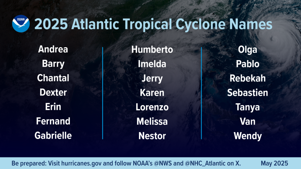
When hurricane season kicks off, so does the use of this year’s storm name list, a tool designed to improve communication and warnings. The first three names have already been used and the next ones, in alphabetical order and alternating between female and male names, are: Dexter, Erin, Fernand, Gabrielle, Humberto, Imelda, Jerry, Karen, Lorenzo, Melissa, Nestor, Olga, Pablo, Rebekah, Sebastien, Tanya, Van and Wendy.
These lists are reused every six years, but the names of especially destructive storms, like Andrew or Katrina, are retired permanently. For example, Dexter replaces Dorian, which was retired after its devastating impact in 2019.
Cooking up a hurricane
Human-caused climate change has also contributed to the rising intensity of hurricanes. Activities like burning fossil fuels and deforestation release large amounts of greenhouse gases, such as carbon dioxide (CO₂) and methane (CH₄).
These gases form a kind of “blanket” that traps heat and drives global warming. More than 90% of this excess heat is absorbed by the oceans, especially the Atlantic. A warmer ocean provides more energy for hurricanes, making them potentially more intense and destructive.
Staying safe during storms and flash floods
Robert Molleda, meteorologist-in-charge at the National Weather Service (NWS), emphasizes the importance of staying informed through multiple channels, including radio, television, weather apps, NOAA Weather Radio and Wireless Emergency Alerts (WEA), which every mobile user should receive.
“Everyone should know their neighborhood’s vulnerability, especially when it comes to flooding. If you live in a flood-prone area, include flood preparedness as a key part of your hurricane plan,” Molleda says.
Among Molleda’s top recommendations: create a family plan that includes the possibility of evacuating your home and prepare an emergency kit or “go bag” ready to take with you if you need to leave.
It’s also important to have a plan in case your family gets separated: write down important phone numbers, keep copies of essential documents (mortgages, insurance, etc.) and don’t forget your medications.
If you have pets, make a plan and prepare a kit for them too.
Hurricanes are part of nature and are not going away, but what we can do is reduce fossil fuel use and adopt a more sustainable lifestyle that helps lower greenhouse gas emissions.
Cira D. Apitz is an editor at VoLo Foundation, a private family organization that exists to accelerate change and global impact by supporting science-based climate solutions, enhancing education and improving health. VoLo Foundation is a financial supporter of The Invading Sea. This piece was originally published at https://volofoundation.org/news/warmer-seas-fuel-a-more-active-and-intense-hurricane-season/.
Sign up for The Invading Sea newsletter by visiting here. To support The Invading Sea, click here to make a donation. If you are interested in submitting an opinion piece to The Invading Sea, email Editor Nathan Crabbe at ncrabbe@fau.edu. Banner photo: Hurricane Dorian at peak intensity (NOAA, via Wikimedia Commons).
